Explore the newest breathtaking routes in Vietnam’s Ha Giang Province
Saturday, May 28, 2022, 11:22 GMT+7


Tourism authorities in Ha Giang Province, northern Vietnam have opened four new routes running through the Dong Van Rock Plateau in the hope of attracting more tourists to the northernmost mountainous region.
The four include Quan Ba – Yen Minh, Yen Minh – Dong Van, Dong Van – Meo Vac, and Meo Vac – Du Gia.
They are considered a true showcase of Ha Giang’s storied beauty.
|
|
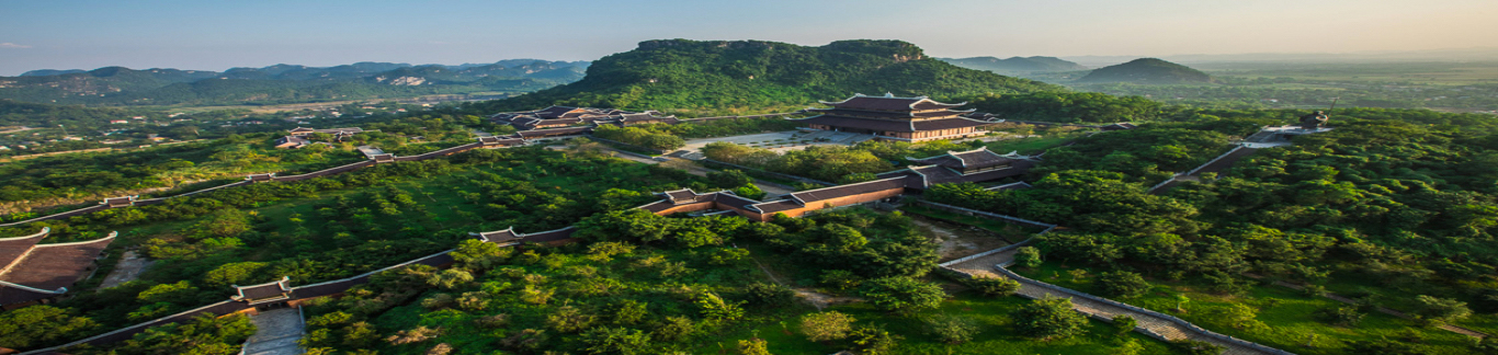
| A stretch of the Ha Giang Loop in Ha Giang Province, Vietnam. Photo: Nhu Binh / Tuoi Tre |
The Ha Giang Loop has long been a favorite amongst motorbike-riding backpackers, but the establishment of the novel routes throughout the region will help to gradually open up the area to group tours and other visitors who prefer to travel by bus or car.
From Quan Ba District to Yen Minh District
Quan Ba District of Ha Giang sits in the southwesternmost area of the Dong Van Karst Plateau Geopark.
To reach the Quan Ba Heaven Gate – a majestic overlook about 1,200 meters above sea level – visitors from Ha Giang City, the provincial capital, must first cross Bac Sum Pass.
The area surrounding Quan Ba is filled with an abundance of geological history owed to the region's vast evolutionary past.
The legend of the Twin Mountains – local lore surrounding two perfectly identical mountains that spring up from rice paddies – is linked to the cultural history of the Mong and Dao peoples.
|
|
| A visitor poses for a photo with the Twin Mountains in the background in Quan Ba District, Ha Giang Province, Vietnam. Photo: Nhu Binh / Tuoi Tre |
From Yen Minh District to Dong Van District
The 80-kilometer route from Yen Minh District to Dong Van District is crammed with switchbacks over towering mountains and past some of Vietnam’s most jaw-dropping scenery.
Along the way, visitors will see Mong villages line the road and filled with traditional homes and rock fences.
|
|
| A young woman poses against a mountainous backdrop in Lung Ho Commune, Ha Giang Province, Vietnam. Photo: Nhu Binh / Tuoi Tre |
Due to a shortage of water and limited arable land, the Mong and other ethnic minorities in Ha Giang have developed a rock-hole soil farming technique that allows them to grow corn.
Rock-hole soil farming utilizes soil in rock holes and rocks to protect the crops. This helps prevent erosion and enables rock holes to be converted into arable land.
Lung Ho Commune is a must-see for travelers along this route.
Visitors will be able to expand their horizons from Lung Ho to ponder the stunning valleys and the alluring village of locals nestled in the spectacular mountains.
From Dong Van District to Meo Vac Distric
The most impressive landmarks along this route are the famous Tu San Canyon, which is Vietnam's deepest alley, the Ma Pi Leng Pass, and Lo Lo Chai Village.
Travelers can also stop at Lung Cu flagpole on top of the Dragon Mountain, Vietnam's northernmost landmark and a popular check-in location for young Vietnamese tourists, as well as the Thanh Nien Xung Phong Monument, which commemorates the touching story of the martyrs who sacrificed themselves for the construction of Happiness Road.
The famous Happiness Road, also known as Ha Giang Loop, was built in 1959 along the Dong Van Rocky Plateau with the total length of 185 kilometers connecting Ha Giang City to the islolated mountainous districts of Quan Ba, Yen Minh, Dong Van, and Meo Vac.
|
|
| Tourists visit Ma Pi Leng Pass in Ha Giang Province, Vietnam. Photo: Nhu Binh / Tuoi Tre |
Vacationers to Lo Lo Chai Village can enjoy a cup of Ca Phe Cuc Bac, which means 'the northernmost café,' at the 200-year-old local café.
Technically, the café is not Vietnam's northernmost point but sipping coffee in an ancient house is a must during a visit to Ha Giang.
From Meo Vac District to Du Gia Commune
Du Gia Commune, located about 70 kilometers from Ha Giang City, captivates tourists with its serene village and unspoilt natural scenery.
According to Nguyen Minh Nam, manager of Tom's homestay, before the COVID-19 pandemic hit Vietnam in 2020, 90 percent of visitors to Du Gia were international tourists.
|
|
| Lo Lo Chai Village, which lies under Dragon Moutain in Lung Cu Commune, Ha Giang Province, Vietnam. Photo: Nhu Binh / Tuoi Tre |
However, the composition of tourists has shifted.
Now, the majority of visitors are domestic, with 60 percent hailing from Vietnam's southern provinces.
|
|
| A rock fence made by Mong ethnic people in Du Gia Commune, Ha Giang Province, Vietnam. Photo: Nhu Binh / Tuoi Tre |
|
|
| A field of blooming buckwheat flowers in Ha Giang Province, Vietnam. Photo: Nhu Binh / Tuoi Tre |
Like us on Facebook or follow us on Twitter to get the latest news about Vietnam!

Several high-rise buildings in Ho Chi Minh City, Hanoi, and Binh Duong Province experienced strong tremors

Skoda aims to scale up its presence in Vietnam through increased investment in production and supply chain development

The Vietnamese rescue team has located and handed over five bodies to the families and authorities in Myanmar

Belgium is in the final stages of ratifying the agreement

A report indicated a significant increase in cyberattacks, data breaches, and security vulnerabilities across the Southeast Asian country

He urged universities from both sides to strengthen cooperation, focusing on new fields such as ocean space, outer space, and underground space exploration

Thailand could suffer a $7 billion to $8 billion export loss from potential U.S. tariffs if the U.S. administration were to even up levies between the two countries, but it has a strategy for trade negotiations, senior officials said on Wednesday
Law enforcement will be on patrol to ensure that everyone follows the rule

Bich Dam is one of the most remote island villages in Nha Trang Bay

Ca Mau Province is home to around 90,000 hectares of mangrove forests
The house has been passed down through six generations

The area is renowned for its stunning natural scenery

The trend of collecting stamps in the ‘Ha Giang Passport’ emerged on social media in late January